
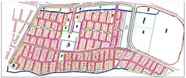
CADASTRAL MAPPING
A cadastral map is a map defining land ownership. The land register cadastral map is further defined by the Act as a map showing all registered geospatial data relating to registered plots. The cadastral map consists of cadastral units, each of which represents a single registered plot of land.
Location
Benin
Client
National Land Commission
Our Scope of work
Analysis of the available cadastral system used by land commission.
Analysis of the property title deeds, authentication procedure transferring title process.
Planning of project architect requirement.
1) Establishment of data centers.
2) Cadastral mapping and Land base creation. – Digitizing of available cadastral maps – Digitizing the satellite images capturing parcels, roads and vacant lands. As per the standard provided
3) Development of Data collection Software.
4) GIS Field work
5) Approval of the data collected from the Government Authorities.
6) Integration of collected data and already existed data with the digitize cadastral maps.
7) Development of GIS based Land Administration System.
8) Training for operating & updating the systems.